Geography: Difference between revisions
No edit summary |
No edit summary |
||
| Line 12: | Line 12: | ||
Includes the regions of Teman, Yyele, Batur, Qran, Ideitess, Shever, and Karber. | Includes the regions of Teman, Yyele, Batur, Qran, Ideitess, Shever, and Karber. | ||
Its highest mountain is thought to be Simemazha in the Great Opal Ranges. | |||
===Baracsa=== | ===Baracsa=== | ||
| Line 18: | Line 20: | ||
Includes the regions of Nor, Umbener, Simber, Seleru, Jadar, and Had. | Includes the regions of Nor, Umbener, Simber, Seleru, Jadar, and Had. | ||
Mount Tauldan in the Great Ranges is considered to be its largest mountain. | |||
| Line 25: | Line 29: | ||
Includes Harda, Tasif, Saron, Sacre, Ikade, Inoti, and Progori regions. | Includes Harda, Tasif, Saron, Sacre, Ikade, Inoti, and Progori regions. | ||
Nganihuntro mountain in the Anwanyisis Mountains is deemed to be the tallest peak. | |||
| Line 31: | Line 37: | ||
The fourth largest continent. | The fourth largest continent. | ||
Includes Hede, Ngoe, and Ashk. | Includes the regions of Hede, Ngoe, and Ashk. | ||
Though fairly flat overall compared to other continents, its tallest peak is believed to be Axrang, in the Red Peaks. | |||
Revision as of 05:29, 8 December 2019

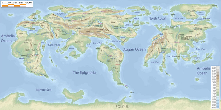
The Five Continents
Armalacsa
The largest landmass on Riiga which includes Armalia and Baracsa.
Armalia
The largest continent.
Includes the regions of Teman, Yyele, Batur, Qran, Ideitess, Shever, and Karber.
Its highest mountain is thought to be Simemazha in the Great Opal Ranges.
Baracsa
The westernmost portion of Armalacsa and third largest continent.
Includes the regions of Nor, Umbener, Simber, Seleru, Jadar, and Had.
Mount Tauldan in the Great Ranges is considered to be its largest mountain.
Suribia
The second largest continent.
Includes Harda, Tasif, Saron, Sacre, Ikade, Inoti, and Progori regions.
Nganihuntro mountain in the Anwanyisis Mountains is deemed to be the tallest peak.
Jindiara
The fourth largest continent.
Includes the regions of Hede, Ngoe, and Ashk.
Though fairly flat overall compared to other continents, its tallest peak is believed to be Axrang, in the Red Peaks.
Solcul
The fifth and smallest continent which sits on the south pole.
Largest Islands
The largest islands in order from biggest to smallest.
Windas
Lies north of Suribia.
Qran
Lies north of Bymir.
Grave Island
Lies northeast of Yyele.
Moonlight Island
Lies south of Karber.
Axhykelran
Lies on the eastern end of Progori.
Nor
Lies north of Umbener.
The Three Oceans
The Epignoria
Lies between Baracsa, Armalia, Jindiara, and Solcul.
Augair Ocean
Lies between Armalia, Jindiara, and Suribia.
Ambelia Ocean
Lies between Suribia and Baracsa.
Major Seas
North Augair
The portion of the Augair which is north of the Augair Peninsula and the Henmi and Tennan islands.
Karber Sea
Lies between Baracsa and Armalia, specifically north of the Sadhihi Islands.
Sea of Lyte
Lies between Umbener and Seleru. A mediterranean sea.
Totani Sea
The sea between Saron and Progori in Suribia.
Itemoe Sea
Lies between Baracsa and Solcul.