Geography: Difference between revisions
From Riiga
Jump to navigationJump to search
(Created page with "750px|thumb|A geographic map of Riiga. For a political map, visit the [[People|People page. ]] g") |
No edit summary |
||
| Line 1: | Line 1: | ||
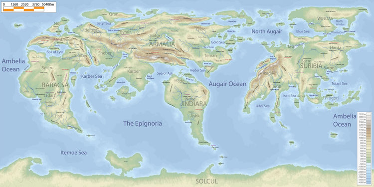
[[File:geogriiga1.jpg|750px|thumb|A geographic map of Riiga. For a political map, visit the [[People|People]] page. ]] | [[File:geogriiga1.jpg|750px|thumb|A geographic map of Riiga. For a political map, visit the [[People|People]] page. ]] | ||
=Armalacsa= | |||
The continent which includes Armalia and Baracsa. | |||
==Armalia== | |||
The largest continent. | |||
Includes the regions of Teman, Yyele, Batur, Qran, Ideitess, Shever, and Karber. | |||
==Baracsa== | |||
The westernmost portion of Armalacsa. | |||
Includes the regions of Nor, Umbener, Simber, Seleru, Jadar, and Had. | |||
=Jindiara= | |||
The third largest continent. | |||
Includes Hede, Ngoe, and Ashk. | |||
=Suribia= | |||
The second largest continent. | |||
Includes Harda, Tasif, Saron, Sacre, Ikade, Inoti, and Progori regions. | |||
==Windas== | |||
The largest island. | |||
=Solcul= | |||
The fourth and smallest continent which sits on the south pole. | |||
Revision as of 04:55, 8 December 2019

A geographic map of Riiga. For a political map, visit the People page.
Armalacsa
The continent which includes Armalia and Baracsa.
Armalia
The largest continent.
Includes the regions of Teman, Yyele, Batur, Qran, Ideitess, Shever, and Karber.
Baracsa
The westernmost portion of Armalacsa.
Includes the regions of Nor, Umbener, Simber, Seleru, Jadar, and Had.
Jindiara
The third largest continent.
Includes Hede, Ngoe, and Ashk.
Suribia
The second largest continent.
Includes Harda, Tasif, Saron, Sacre, Ikade, Inoti, and Progori regions.
Windas
The largest island.
Solcul
The fourth and smallest continent which sits on the south pole.