World Maps: Difference between revisions
From Riiga
Jump to navigationJump to search
No edit summary |
No edit summary |
||
| Line 1: | Line 1: | ||
==Realistic Biomes== | |||
* Polar/Ice | |||
** Freezing cold land covered primarily in packed ice which sees little sunlight. | |||
* Tundra | |||
** A cold, barren land with frozen soil, almost no trees, and short growing seasons allowing only grasses, shrubs, and mosses. | |||
* Taiga | |||
** Cold forests mostly containing evergreen conifers, with very short summers and cold, snowy winters. | |||
* Alpine Tundra | |||
** A high-altitude, treeless, freezing area with thin air which may be covered in snow throughout the whole year. | |||
* Montane Forest | |||
** High-elevation deciduous forest lands that may be cool or warm depending on their place in the world. | |||
* Temperate Forest | |||
** Forests mostly made of deciduous trees that see distinct warm summers and cool winters. | |||
* Temperate Grassland | |||
** Grassland which sees freezing winters and hot summers, tough grasses, and low rainfall. | |||
* Savanna | |||
** Grassland which experiences heavy rainfall in one season, but is otherwise quite dry and warm. | |||
* Wooded Savanna | |||
** Savanna filled with low-density trees that do not create a canopy. | |||
* Subtropical Forest | |||
** Forest that sees high precipitation, warm weather, and humidity, with a distinct canopy. | |||
* Monsoonal Forest | |||
** Deciduous forest that experiences a long dry season followed by a season of extreme rainfall. | |||
* Subtropical Rainforest | |||
** Tall forests that see regular rainfall but experience a short dry season, with a multi-layered canopy and rich soils. | |||
* Tropical Rainforest | |||
** Tall, lush rainforests that see heavy continuous rainfal and no dry season, with several distinct canopies and poor soil quality. | |||
* Mediterranean | |||
** Land with cool and wet winters and dry summers, with most rainfall falling during winter and a lot of sunlight. | |||
* Dry Grassland | |||
** Cool grassy lands with low-growing vegetation and patchy coverage, perfect for grazing animals. | |||
* Semiarid Desert | |||
** A desert with less sand dunes and more barren rocky ground that sees a wide range of temperatures. | |||
* Arid Shrubland | |||
** Land with very little rainfall covered mostly in sparse shrubs and stones rather than sand dunes. | |||
* Arid Desert | |||
** A very cold or very hot barren, dusty land with almost no precipitation, hostile toward most flora and fauna. | |||
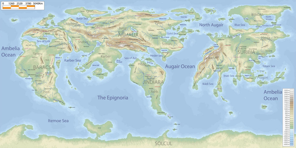
[[File:geogriiga1.jpg|1000px|thumb|A geographic map of Riiga showing biome distribution. Natural phenomena are marked in red and natural wonders are marked in purple.]] | [[File:geogriiga1.jpg|1000px|thumb|A geographic map of Riiga showing biome distribution. Natural phenomena are marked in red and natural wonders are marked in purple.]] | ||
Revision as of 10:43, 14 February 2020
Realistic Biomes
- Polar/Ice
- Freezing cold land covered primarily in packed ice which sees little sunlight.
- Tundra
- A cold, barren land with frozen soil, almost no trees, and short growing seasons allowing only grasses, shrubs, and mosses.
- Taiga
- Cold forests mostly containing evergreen conifers, with very short summers and cold, snowy winters.
- Alpine Tundra
- A high-altitude, treeless, freezing area with thin air which may be covered in snow throughout the whole year.
- Montane Forest
- High-elevation deciduous forest lands that may be cool or warm depending on their place in the world.
- Temperate Forest
- Forests mostly made of deciduous trees that see distinct warm summers and cool winters.
- Temperate Grassland
- Grassland which sees freezing winters and hot summers, tough grasses, and low rainfall.
- Savanna
- Grassland which experiences heavy rainfall in one season, but is otherwise quite dry and warm.
- Wooded Savanna
- Savanna filled with low-density trees that do not create a canopy.
- Subtropical Forest
- Forest that sees high precipitation, warm weather, and humidity, with a distinct canopy.
- Monsoonal Forest
- Deciduous forest that experiences a long dry season followed by a season of extreme rainfall.
- Subtropical Rainforest
- Tall forests that see regular rainfall but experience a short dry season, with a multi-layered canopy and rich soils.
- Tropical Rainforest
- Tall, lush rainforests that see heavy continuous rainfal and no dry season, with several distinct canopies and poor soil quality.
- Mediterranean
- Land with cool and wet winters and dry summers, with most rainfall falling during winter and a lot of sunlight.
- Dry Grassland
- Cool grassy lands with low-growing vegetation and patchy coverage, perfect for grazing animals.
- Semiarid Desert
- A desert with less sand dunes and more barren rocky ground that sees a wide range of temperatures.
- Arid Shrubland
- Land with very little rainfall covered mostly in sparse shrubs and stones rather than sand dunes.
- Arid Desert
- A very cold or very hot barren, dusty land with almost no precipitation, hostile toward most flora and fauna.
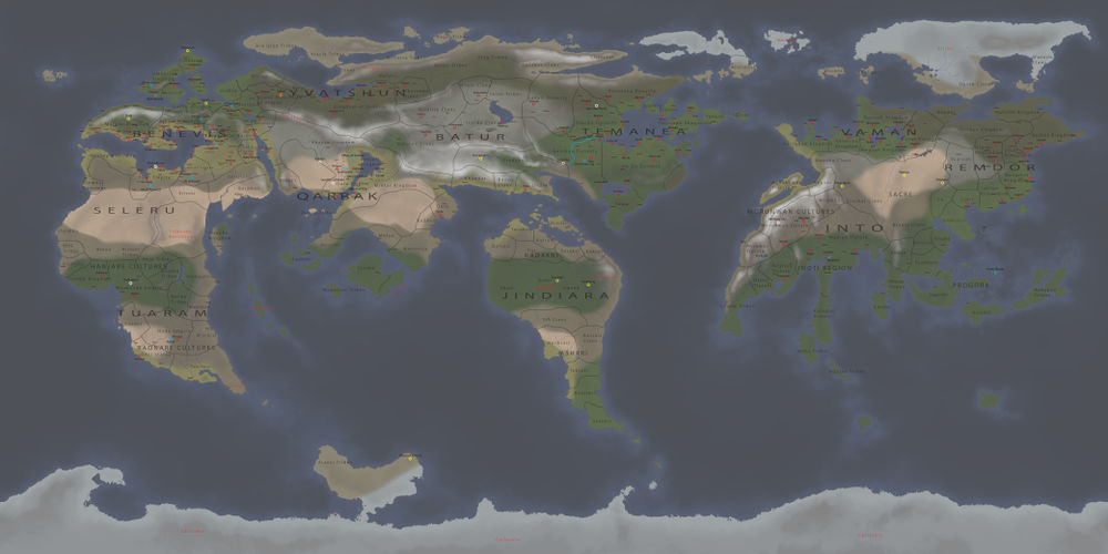
A political map showing empires, kingdoms, states, tribal groups, and clans, as well as the largest cities of Riiga. Each city marked represents a population of 10,000,000 both within it and in the surrounding area. It also shows known Archaios locations, and man-made Wonders of certain (blue) or uncertain (white) locations.
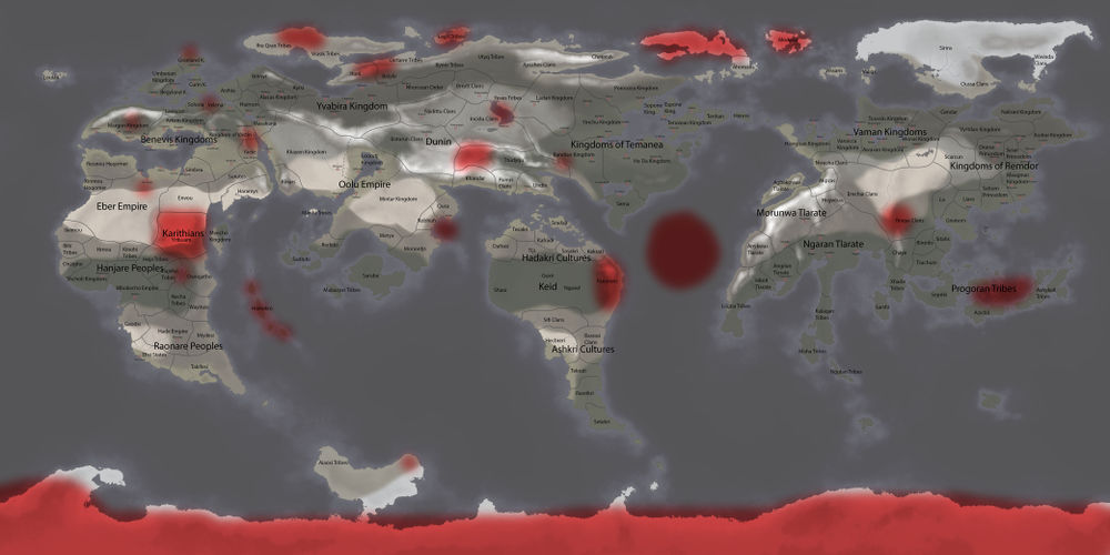
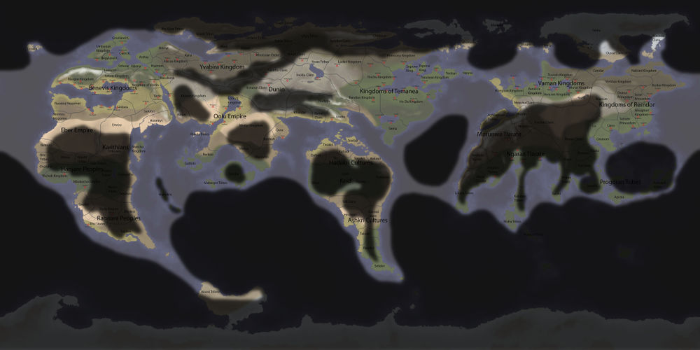
A map of current and historical sites of heavy monster or monster-race activity.
