|
|
| (16 intermediate revisions by the same user not shown) |
| Line 1: |
Line 1: |
| [[File:riigabiomes.jpg|700px|thumb|A biome map of Riiga.]]
| |
|
| |
| An article by Virgil on [[Benevis Mapping]]. | | An article by Virgil on [[Benevis Mapping]]. |
|
| |
|
| ==Realistic Biomes==
| | The official [https://bheiskell.github.io/riiga-timeline-map/ historical slideshow map] of Riiga. |
| * '''Polar/Ice''' - Freezing cold land covered primarily in packed ice which sees little sunlight.
| |
| * '''Tundra''' - A cold, barren land with frozen soil, almost no trees, and short growing seasons allowing only grasses, shrubs, and mosses.
| |
| * '''Taiga''' - Cold forests mostly containing evergreen conifers, with very short summers and cold, snowy winters.
| |
| * '''Alpine Tundra''' - A high-altitude, treeless, freezing area with thin air which may be covered in snow throughout the whole year.
| |
| * '''Montane Forest''' - High-elevation deciduous forest lands that may be cool or warm depending on their place in the world.
| |
| * '''Temperate Forest''' - Forests mostly made of deciduous trees that see distinct warm summers and cool winters.
| |
| * '''Temperate Grassland''' - Grassland which sees freezing winters and hot summers, tough grasses, and low rainfall.
| |
| * '''Savanna''' - Grassland which experiences heavy rainfall in one season, but is otherwise quite dry and warm.
| |
| * '''Wooded Savanna''' - Savanna filled with low-density trees that do not create a canopy.
| |
| * '''Subtropical Forest''' - Forest that sees high precipitation, warm weather, and humidity, with a distinct canopy.
| |
| * '''Subtropical Rainforest''' - Tall forests that see regular rainfall but experience a short dry season, with a multi-layered canopy and rich soils.
| |
| * '''Monsoonal Forest''' - Deciduous forest that experiences a long dry season followed by a season of extreme rainfall.
| |
| * '''Tropical Rainforest''' - Tall, lush rainforests that see heavy continuous rainfal and no dry season, with several distinct canopies and poor soil quality.
| |
| * '''Mediterranean''' - Land with cool and wet winters and dry summers, with most rainfall falling during winter and a lot of sunlight.
| |
| * '''Dry Grassland''' - Cool grassy lands with low-growing vegetation and patchy coverage, perfect for grazing animals.
| |
| * '''Semiarid Desert''' - A desert with less sand dunes and more barren rocky ground that sees a wide range of temperatures.
| |
| * '''Arid Shrubland''' - Land with very little rainfall covered mostly in sparse shrubs and stones rather than sand dunes.
| |
| * '''Arid Desert''' - A very cold or very hot barren, dusty land with almost no precipitation, hostile toward most flora and fauna.
| |
| | |
| ==Riigan Biomes==
| |
| * '''Glass Mountains''' - Due to mountains made of shimmering stone, glass mountain regions suffer from no vegetation whatsoever thanks to the storms of glass grains.
| |
| * '''Hills of Burden''' - A region in the Pearl Mountains which are really difficult to climb, causing them to be mostly void of trees and wildlife.
| |
| * '''Blightlands''' - Tropical forested land filled with poisonous plants and animals due to the natural toxic blight bursts that occur there.
| |
| * '''Burning Rainlands''' - A barren, toxic region that experiences rain that slowly dissolves organic material.
| |
| * '''Blue Night''' - A temperate, humid region which sees heavy blue-tinted seasonal fog, shrouding the land in darkness.
| |
| | |
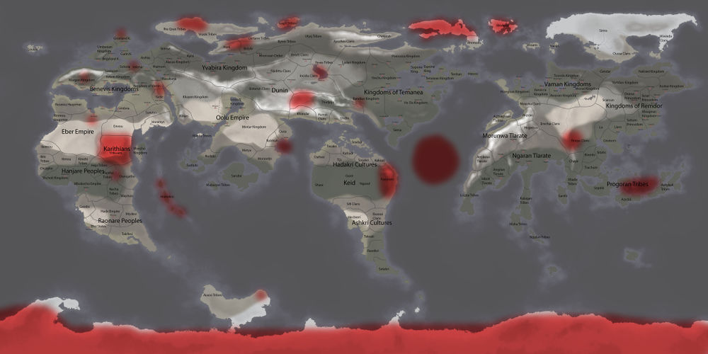
| [[File:geogriiga1.jpg|1000px|thumb|A physical map of Riiga coloured by altitude. Natural phenomena are marked in red and natural wonders are marked in purple.]]
| |
|
| |
|
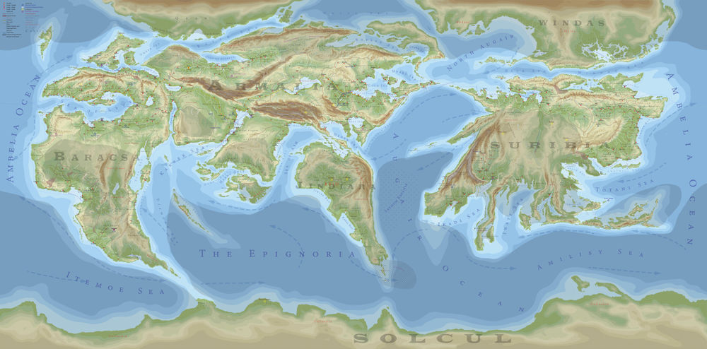
| [[File:riigacities.jpg|1000px|thumb|A political map showing empires, kingdoms, states, tribal groups, and clans, as well as the largest cities of Riiga. | | [[File:Geopoliticalriiga.jpg|1000px|thumb|A geopolitical map of Riiga coloured by altitude. The key is in the upper left corner. This map is not to scale, but does represent the shapes of the landmasses most accurately; other maps on this page are outdated in this regard.]] |
| | |
| Each city marked represents a population of 10,000,000 both within it and in the surrounding area.
| |
| | |
| It also shows known [[Archaios]] locations, and man-made [[Wonders]] of certain (blue) or uncertain (white) locations.]]
| |
| | |
| [[File:knownriiga.jpg|1000px|thumb|A map of showing which areas are well known and which are unknown, very poorly known, or knowledge given by a third party.]]
| |
|
| |
|
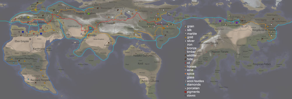
| [[File:riigatrade.jpg|1000px|thumb|A map of major trade routes in among the connected Riigan cultures. Red: The Archroad. Orange: Archroad connections. Aqua: The main sea trading routes. Blue: The Diamond Route. Goods shown are only of major sources.]] | | [[File:riigatrade.jpg|1000px|thumb|A map of major trade routes in among the connected Riigan cultures. Red: The Archroad. Orange: Archroad connections. Aqua: The main sea trading routes. Blue: The Diamond Route. Goods shown are only of major sources.]] |
| Line 45: |
Line 10: |
|
| |
|
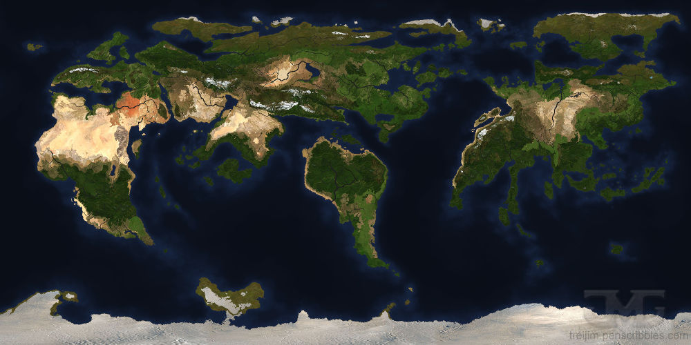
| [[File:texturedmap.jpg|1000px|thumb|A textured map of Riiga designed to look like satellite imagery.]] | | [[File:texturedmap.jpg|1000px|thumb|A textured map of Riiga designed to look like satellite imagery.]] |
| | |
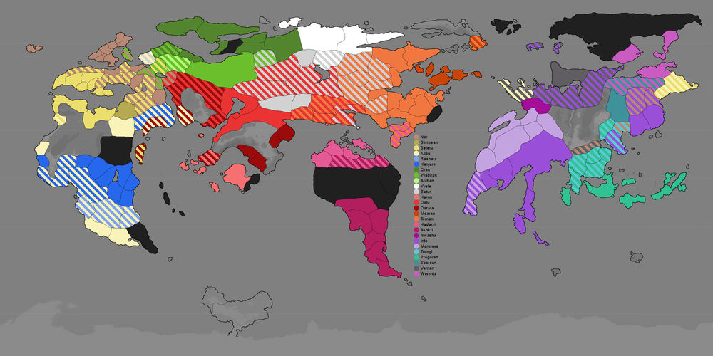
| | [[File:racesmap.jpg|1000px|thumb|An ethnic map of Riiga. See [[Ethnicity]] for more information.]] |
