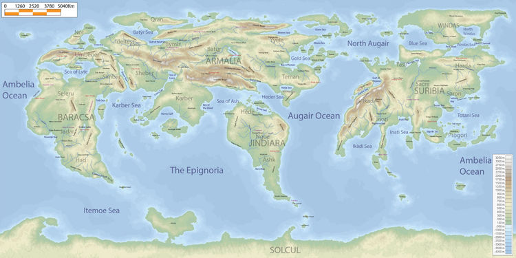
Geography

The Five Continents
Armalacsa
The largest landmass on Riiga which includes Armalia and Baracsa.
Armalia
The largest continent.
Includes the regions of Teman, Yyele, Batur, Qran, Ideitess, Shever, and Karber.
Baracsa
The westernmost portion of Armalacsa and third largest continent.
Includes the regions of Nor, Umbener, Simber, Seleru, Jadar, and Had.
Suribia
The second largest continent.
Includes Harda, Tasif, Saron, Sacre, Ikade, Inoti, and Progori regions.
Windas
The largest island.
Jindiara
The fourth largest continent.
Includes Hede, Ngoe, and Ashk.
Solcul
The fifth and smallest continent which sits on the south pole.
The Three Oceans
The Epignoria
Lies between Baracsa, Armalia, Jindiara, and Solcul.
Augair Ocean
Lies between Armalia, Jindiara, and Suribia.
Ambelia Ocean
Lies between Suribia and Baracsa.
Major Seas
North Augair
The portion of the Augair which is north of the Augair Peninsula and the Henmi and Tennan islands.
Karber Sea
Lies between Baracsa and Armalia, specifically north of the Sadhihi Islands.
Sea of Lyte
Lies between Umbener and Seleru. A mediterranean sea.
Totani Sea
The sea between Saron and Progori in Suribia.
Itemoe Sea
Lies between Baracsa and Solcul.